Dense Fog Advisory issued September 22 at 11:43PM EDT until September 23 at 10:00AM EDT by NWS Wilmington OH (details ...)
* WHAT...Visibility one quarter mile or less in dense fog.
* WHERE...Portions of east central and southeast Indiana and southwest and west central Ohio.
* WHEN...Until 10 AM EDT Tuesday.
* IMPACTS...Low visibility could make driving conditions hazardous.
63° 63° likely chance Tue 80° Tue 80° chance 62° 62° chance Wed 73° Wed 73° likely
Thursday, August 25th, 2011
Submitted Photo

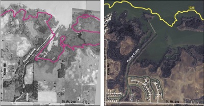
These aerial photos of the Prairie Creek area on the south side of Grand Lake show the loss of littoral wetlands in 70 years. The photo on the left is from 1938 and the magenta line marks the current shore line. The photo on the right is from 2009 and the 1938 shore line is marked in yellow. By 1973, the wetlands disappeared due to land development, increased runoff and the loss of adequate vegetation along the shoreline, according to the Ohio EPA. Sources: 1938 photo from the Mercer County Engineer's Office, 2009 photo from the Mercer County Tax Map Department.

Related online story:
GRAND LAKE - Re-creating the past may be a remedy for the future of Grand Lake.
Officials are working on a plan to restore a type of wetlands destr [More]
Additional pictures on this date